
Defense Arabia · Analysis · July 22, 2026
From Satellites to Data Centers
The Iran Conflict and the Expansion of the Modern Battlespace
The conflict involving Iran since February 2026 has made it unmistakably clear: the battlespace now extends from satellites in orbit to the energy and digital infrastructure that sustain modern economies.


Foreword Dr. Salem El Nimri
Space, cyber, energy, and AI are converging into a single, layered strategic environment.
The conflict involving Iran since February 2026 has exposed how space assets, commercial geospatial intelligence, AI infrastructure, and critical energy facilities have become deeply interlinked, and how they are now treated as both levers of strategic advantage and high-value targets during conflicts.
In this report, coauthored by Dr. Béatrice Hainaut and Anna Hazlett, readers are offered a rigorous and timely examination of this expanded battlespace. Drawing on operational experience in military space and a decade of advisory work on space and strategic technologies in the Gulf, the authors trace how access to non-indigenous space capabilities, the use of commercial satellite imagery for targeting, and the proliferation of GNSS jamming and spoofing are reshaping security dynamics across the region. They show how measures designed to gain tactical advantage can ripple outward into civilian domains, affecting maritime safety, financial systems, logistics networks, and the broader commercial ecosystem.
Equally important is the report’s focus on the ground segment: satellite control centers, missile defense radar networks, digital infrastructure for AI computing, and energy infrastructure that anchor national strategies for growth and diversification. The documented strikes on key energy and critical infrastructure across the Gulf illustrate a fundamental shift in how such infrastructure is perceived, from enablers of economic growth to central elements of national power. For Gulf states that already devote a high share of GDP to defense, this is influencing not only the level of spending, but also its composition, with increasing emphasis on space-enabled capabilities, resilient navigation, infrastructure hardening, and redundancy by design.
What emerges is more than a chronology of events. This study offers a framework for understanding how space, cyber, energy, and AI are converging into a single, layered strategic environment that will shape future competition and cooperation alike. It argues that resilience, governance, and cross-sector coordination around critical infrastructure must move to the core of both defense planning and economic strategy, particularly in high-growth space economies such as those of the Gulf.
Dr. Salem El Nimri
Since February 28, the Middle East has experienced another period of conflict, bringing renewed instability to the region. The situation remains dynamic, with the strategic and operational implications still emerging. At the time of writing, active hostilities appear to be diminishing, yet significant uncertainty remains regarding the implementation of current agreements and the conditions required for a lasting peace. Governments, businesses, and critical infrastructure operators must therefore continue planning for uncertainty and disruption. Resilience and adaptability have become as important as predicting outcomes.
Since the beginning of the war, the Gulf states have found themselves on the front line, in the most literal sense of the term. The Iranian regime’s strategy has been to systematically target American military installations across the region and, in some cases, civilian targets representing American interests. There is little doubt that space support to military operations has been necessary for Iran. On the other side, it is equally clear that the United States relied on satellite capabilities to plan and conduct military operations.
While the military use of space is not new, the fact that Iran now has access to advanced non-indigenous space capabilities is particularly noteworthy. Moreover, the apparent targeting of data centres may represent a first in contemporary warfare.
What does this tell us about the modern battlespace?
Section 01 · Orbit LEO · ~500 KM
Satellite Imagery as Critical Data
Iran possesses its own space capabilities, although these remain limited in scale. However, it is well established that the country has benefited from external space support from its allies, particularly Russia[1] and China[2]. Furthermore, according to the Financial Times[3], an Earth-observation satellite known as TEE-01B, manufactured and launched by China in June 2024, was reportedly transferred to the Aerospace Force of the Islamic Revolutionary Guard Corps (IRGC) several months after launch. According to the investigation, the IRGC would therefore have been able to task the satellite and access its imagery through Chinese commercial ground stations. China has denied these allegations. At first glance, such support would not be particularly surprising given the cordial diplomatic relations between the two countries. Nevertheless, it is worth noting that China now possesses a range of optical imaging capabilities, both in terms of quantity and performance, potentially capable of supporting targeting missions.
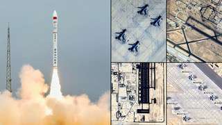
The growing importance of satellite imagery reflects a broader transformation of the Earth-observation sector over the past decade. Historically, high-resolution geospatial intelligence was largely the preserve of governments and intelligence agencies, with access to imagery tightly controlled and often classified. Today, a rapidly expanding commercial ecosystem has fundamentally altered this landscape. Companies such as Planet Labs, VANTOR (formerly MAXAR Technologies), Airbus Defence and Space, ICEYE, Capella Space, BlackSky and others operate constellations capable of providing increasingly frequent global coverage, in some cases revisiting the same location multiple times per day. Driven by lower launch costs, advances in small satellite technologies, cloud-based data distribution, and artificial intelligence, commercial capabilities have expanded at a pace that often exceeds traditional government acquisition cycles.
This transformation extends beyond Earth observation. The widespread use of SpaceX’s Starlink constellation during the war in Ukraine demonstrated how commercial space infrastructure can rapidly become critical to military operations, government continuity, and civilian communications. Together, these developments illustrate how capabilities once associated almost exclusively with governments are increasingly being delivered by commercial operators at global scale.
As a result, governments themselves increasingly rely on commercial providers to supplement national capabilities, while the same technologies are becoming accessible to a far broader range of actors than was previously possible.
What appears to have been more problematic for the United States and its allies, however, was the possibility that Iran may have been able to rely on commercially available Western space support for targeting operations[4], particularly given that such data are not classified by nature. In practice, during the conflict involving Iran, American commercial actors themselves introduced restrictions following a CNN report[5] in which journalists claimed that, after one week of hostilities, Iran had targeted nine American military positions in less than forty-eight hours. Their reporting relied on satellite imagery provided by VANTOR and Planet Labs.
Planet Labs has decided to take additional, proactive measures to ensure our imagery is not tactically leveraged by adversarial actors to target allied and NATO-partner personnel and civilians.Planet Labs statement[7]
Planet Labs initially decided to impose a delay of 96 hours[6] and subsequently 14 days before delivering imagery covering Iran, the Persian Gulf, American military bases, and “existing conflict zones”. The company stated that this decision had been taken on its own initiative. Planet Labs later moved to a system of managed distribution, releasing imagery on a case-by-case basis for urgent, mission-critical requirements or in the public interest.
VANTOR also introduced controls on all new satellite imagery requests. The United States already possesses an existing regulatory framework, notably through licensing systems and shutter control mechanisms, although this framework is likely to evolve further in the coming years. Given the growing strategic significance of commercial geospatial intelligence, further evolution of licensing, access-control and dissemination frameworks should be expected across multiple jurisdictions[8].
The issue of dissemination becomes more complex with the existence of companies operating as genuine “image banks.” These firms source imagery from multiple commercial operators, which can make attempts to control distribution considerably more difficult. As a result, the Chinese company MizarVision[9] was reportedly able to publish several images showing American military preparations in Jordan and the Persian Gulf before the strikes of 28 February. Although the precise origin of these images remains unclear, analysts believe that some display characteristics associated with imagery from Western commercial providers[10].
More broadly, the strategic significance of commercial geospatial intelligence extends well beyond individual satellite images. Modern Earth observation increasingly relies on constellations of optical and Synthetic Aperture Radar (SAR) satellites capable of providing frequent revisit rates and, in the case of SAR, all-weather, day-and-night imaging. Combined with advances in artificial intelligence, these capabilities enable the automated detection, classification, and tracking of military assets, infrastructure, logistics movements, and changes in activity across large geographic areas. Rather than relying on a single image, users can increasingly access a near-continuous stream of observations that can be fused, analysed, and acted upon in near real time.
The rapid expansion of commercial Earth-observation capabilities means that what was once the exclusive domain of national intelligence agencies is increasingly available through the commercial marketplace, often with update cycles, revisit rates, and analytical tools that continue to improve year-on-year. While the full extent of the information available to actors in the conflict remains unknown, the demonstrated accuracy and responsiveness of modern military operations underscore a broader reality: commercially available space capabilities, coupled with AI-enabled analytics, are narrowing the gap between traditional state intelligence functions and services available through the commercial marketplace.
Section 02 · Signal GNSS · MEO · 20,200 KM
GNSS Disruption
GPS disruption has also become another defining characteristic of recent conflicts, and the war involving Iran is no exception. Jamming and spoofing have become routine occurrences whose consequences for civilian activities can be severe. Jamming disrupts a vehicle’s satellite-based positioning capabilities, while spoofing causes navigation systems to report false locations.
A wide range of economic activities depend on GPS synchronisation, which provides not only positioning capabilities from space but also highly precise timing information. Numerous systems, including financial transactions, rely on Global Navigation Satellite Systems (GNSS) as an extremely precise time reference.
Over the Strait of Hormuz, electromagnetic interference creates significant risks for maritime safety and navigation by increasing the likelihood of collisions between vessels. However, such interference has become a recurring feature of contemporary conflicts, in order to counter GPS-guided missiles and drones used by their adversaries[11].
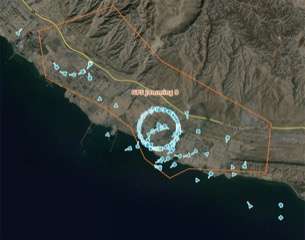
During periods of heightened tension in the Gulf, widespread GPS interference in and around the Strait of Hormuz has caused commercial vessels to report false positions, with some ships appearing to be located on land, at airports, or many kilometres from their actual location. While such measures are often intended to degrade the effectiveness of GPS-guided drones, missiles and other autonomous systems, they can simultaneously affect civilian shipping, logistics and maritime safety. This illustrates how tools once confined to the military domain are increasingly generating economic and operational consequences across the wider commercial ecosystem, with effects extending to the navigation services relied upon by millions of civilian users.
Consequently, the proliferation of GNSS jamming and spoofing is accelerating demand for alternative positioning, navigation and timing (PNT) capabilities that can operate in degraded or denied environments. As military and commercial operators become increasingly exposed to GPS disruption, a growing ecosystem of companies is emerging to address this vulnerability. Firms such as Rhea Space Activity are developing GPS-independent navigation solutions designed to enable spacecraft and autonomous systems to determine their position without relying exclusively on satellite navigation signals. What was once viewed as a niche defence requirement is increasingly becoming a commercial and strategic necessity.
At the same time, governments are increasingly investing in alternative and complementary PNT architectures to reduce dependence on GPS alone. Beyond the United States’ GPS constellation, operators today can access other global systems including Europe’s Galileo, China’s BeiDou and Russia’s GLONASS, while a growing number of regional and commercial initiatives are exploring terrestrial PNT networks, low-Earth orbit navigation services, and hybrid navigation architectures. The objective is to create greater redundancy and resilience in environments where satellite navigation signals may be degraded, denied, or manipulated.
The rapid expansion of large commercial constellations has further accelerated this trend. In particular, SpaceX has stated to the U.S. Federal Communications Commission (FCC) that its Starlink constellation is capable of supporting positioning, navigation and timing services[12]. Because Starlink satellites operate in low Earth orbit, their signals are significantly stronger than traditional GNSS signals and therefore potentially more resilient to jamming and interference. The constellation’s scale, frequency diversity, beam-forming capabilities, and ability to rapidly update software across thousands of satellites have demonstrated how commercial operators can adapt to electronic warfare threats at a pace often difficult to replicate through traditional government acquisition cycles.
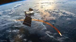
More broadly, the conflict highlights how modern warfare is driving innovation far beyond the traditional defence industrial base. Just as cyberattacks accelerated investment in cybersecurity, persistent GNSS disruption is creating demand for resilient navigation, timing and autonomy technologies across both government and commercial markets. In doing so, the conflict is helping shape and clearly accelerating the development of the next generation of infrastructure that will underpin military operations, transportation networks, autonomous systems and critical digital services.
Section 03 · Ground Surface · 0 M
Critical Infrastructures Under Threat
This conflict also highlights the vulnerability of critical infrastructure. Ground-based space infrastructure has, for example, become a target of military operations. The Israeli military announced that it had struck the command-and-control centre of the Iranian Earth-observation satellite Kayyam, arguing that it constituted a threat to Israel and regional states[13]. Similarly, at least five American satellite communication terminals were reportedly targeted across the region[14], although Iranian strikes primarily focused on U.S. missile defence radar systems[15]. The attacks against satellite communication terminals aimed to isolate American bases from the outside world.
Beyond individual military installations, the reported targeting of radar and communications systems across Qatar, the UAE and other Gulf states illustrates how regional missile-defence and early-warning networks have themselves become strategic targets. Regardless of the accuracy of individual claims, the broader lesson is clear: modern military effectiveness increasingly depends upon interconnected networks of sensors, communications links, satellites and data-processing infrastructure, making the wider information architecture itself a potential target during conflict. These systems derive much of their strategic value not from their individual capabilities, but from the role they play within the wider network that enables military operations. Their targeting reflects the extent to which contemporary conflicts increasingly focus on disrupting the information architecture that underpins military power.
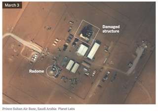
Ground space infrastructure is not the only “new” category of target emerging from this conflict. The targeting of commercial data centres has also attracted considerable attention. International reporting, including statements[16] by Amazon Web Services (AWS), indicated that facilities in the UAE and Bahrain sustained damage during the conflict, resulting in disruptions to cloud services, while data centre infrastructure operated by Oracle was also reportedly targeted. Regardless of the precise circumstances of individual incidents, the episode highlighted the growing strategic importance of commercial digital infrastructure during periods of geopolitical tension. Iranian authorities appear to have fully recognised that these infrastructures have become critical assets for many powers that increasingly regard artificial intelligence, both in its civilian and military applications, as a strategic and financial resource. Data centres have become essential pillars of the economic diversification strategies pursued by several Gulf states, particularly the UAE.
This dynamic was further underscored by reports that Iranian officials had threatened to target the planned OpenAI Stargate UAE data centre, a project forming part of a multi-billion-dollar effort to establish one of the world’s largest AI computing hubs in Abu Dhabi. The threat highlighted the extent to which advanced computing infrastructure is increasingly being viewed through a strategic and national security lens, alongside more traditional military and critical infrastructure targets.
AI infrastructure such as commercial data centers is a growing part of U.S. leadership in the region, and this war could jeopardize the future of AI infrastructure in the Gulf.Assessment cited in the report[17]

Although the conflict appears to be entering a less acute phase, the underlying observation remains relevant: advanced computing infrastructure is increasingly becoming a matter of strategic competition and national security, rather than solely a commercial concern.
Energy infrastructure has similarly emerged as a central target category during the conflict. Oil refineries, gas processing facilities, fuel depots, export terminals and associated logistics infrastructure have all been subjected to strikes across multiple countries in the region. Israeli attacks on Iran’s South Pars gas field and associated energy facilities were followed by Iranian threats and retaliatory actions targeting energy infrastructure in Qatar, Saudi Arabia and the UAE, including assets linked to LNG production and oil exports. The conflict demonstrated the extent to which energy systems are increasingly viewed not only as economic assets, but as strategic infrastructure capable of generating significant geopolitical, financial and operational effects far beyond the immediate battlespace. The targeting of such facilities contributed to volatility in global energy markets, renewed concerns over energy security, and heightened risks to critical supply chains dependent on Gulf energy exports.
Additional protective measures for these large and vulnerable strategic sites can therefore be expected, as they increasingly appear to be regarded as legitimate targets during wartime. Indeed, the UAE has reportedly begun implementing additional physical protective structures around key energy infrastructure assets in response to the growing threat posed by drones and precision-guided munitions, reflecting a broader shift towards infrastructure hardening and resilience in high-risk operating environments[18]. However, resilience is unlikely to be achieved through hardening alone. The growing vulnerability of concentrated infrastructure may also accelerate investment in distributed energy systems, microgrids, and localized generation capabilities, reducing single points of failure and enabling critical services to continue operating even when central infrastructure is degraded or disrupted.
In the future, an increasing range of infrastructures that are not inherently military, but that underpin strategic national capabilities could become targets in the context of armed conflict. The conflict demonstrated that energy facilities, communications networks, data centres, AI computing infrastructure and other critical economic assets are increasingly being viewed through a strategic and national security lens. Besides, according to the Financial Times[19], these kinds of attacks have a potential financial consequence: the perception of risk may evolve among investors, insurers, and technology companies seeking to develop projects in the region.
By the numbers
The conflict in figures: pressure on spending, imagery, and infrastructure
of GDP: the Middle East recorded the highest military burden globally in 2025[20]
American military positions reportedly targeted by Iran in under forty-eight hours, per CNN reporting[5]
Planet Labs’ escalating delay on imagery covering Iran, the Gulf and conflict zones[6]
rise in European military expenditure in 2025, accelerated by the war in Ukraine and expected to continue through 2026
Conclusion Outlook
Just as the war in Ukraine accelerated defence investments in Europe, the conflict involving Iran may reinforce the ongoing increase in defence spending among Gulf states, which are on the front line of this conflict.
Although this trend was already observable prior to 28 February 2026, recent events have reinforced the importance of planning for disruption rather than attempting to predict outcomes. For states operating in volatile environments, resilience, redundancy, and preparedness are increasingly becoming strategic necessities rather than optional investments.
The composition of this spending may also evolve, with an increasing share directed towards space-enabled capabilities such as satellite communications, Earth observation, missile warning and resilient navigation systems. The conflict has reinforced the extent to which these capabilities have become fundamental components of modern military power and strategic deterrence.
More broadly, the events examined in this paper demonstrate how the modern battlespace now extends far beyond traditional military domains. From satellites and communications networks to energy infrastructure, data centres and artificial intelligence computing facilities, assets once regarded primarily as commercial or civilian are increasingly being viewed through a strategic and national security lens. As states adapt to this new reality, resilience, redundancy and the protection of critical infrastructure are likely to become defining features of both defence planning and economic strategy in the years ahead.
Notes & Sources
- Raf Sanchez, Charlene Gubash, “Russia took satellite images of U.S. air base in days before Iranian attack, Ukraine’s Zelenskyy says”, NBC News, March 28, 2026.
- Gia Chaudry, “When Satellite Data Becomes a Weapon”, Wired, March 25, 2026.
- Miles Johnson, Peter Andringa, Alison Killing, Charles Clover et Demetri Sevastopulo, “Iran used Chinese spy satellite to target US bases”, Financial Times, April 15, 2026.
- Joanne Stocker, “Satellite companies curb access to Mideast imagery over concern it could be used by adversarial actors”, CBS News, March 19, 2026.
- CNN Investigates: How Iran strikes have damaged US military sites, CNN, March 3, 2026.
- Stephen Clark, “Satellite firm pauses imagery after revealing Iran’s attacks on US bases”, Ars Technica, March 6, 2026.
- Joanne Stocker, “Satellite companies curb access to Mideast imagery over concern it could be used by adversarial actors”, CBS News, March 19, 2026.
- NOAA Commercial Remote Sensing Regulatory Affairs (CRSRA), including ongoing reviews of licensing frameworks and national security-related operating conditions for U.S. commercial remote sensing systems (2023–2025).
- Ryan Finnerty, “Chinese intelligence company tracking US military assets during Iran operations”, Flight Global, March 2, 2026.
- Cate Cadell, Lyric Li, “Chinese firms market Iran war intelligence ‘exposing’ U.S. forces”, The Washington Post, April 4, 2026.
- Chris Baraniuk, “GPS jamming: The invisible battle in the Middle East”, BBC, March 10, 2026; Katie Hunt, “GPS jamming and its use in the Iran war, explained”, CNN, March 6, 2026.
- SpaceX, Response to the U.S. Federal Communications Commission (FCC) Notice of Inquiry on Positioning, Navigation and Timing (PNT), May 2025.
- Laure-Maïssa Farjallah, “In Iran, Israel targets Khayyam satellite control center”, L’Orient Today, March 10, 2026.
- “Iran Strikes U.S. Military Communication Infrastructure in Mideast”, The New York Times, March 1, 2026.
- Victoria Beaule, Peter Charalambous, Kerem Inal, “US and allied radar sites in the Middle East struck at least 10 times: Visual analysis”, ABC News, March 18, 2026.
- Shubham Kalia, Aditya Soni and Mrinmay Dey, “Amazon cloud unit’s data centers in UAE, Bahrain damaged in drone strikes”, Reuters, March 3, 2026.
- Dennis Murphy, “Why Iran targeted Amazon data centers and what that does, and doesn’t, change about warfare”, The Conversation, April 2, 2026.
- Howard Altman, “UAE Building Massive ‘Cope Cages’ To Protect Energy Facilities From Iranian Drone Attacks”, The War Zone, May 13, 2026.
- Rafe Rosner-Uddin, Tim Bradshaw, Sam Learner, “Iran hits Amazon data centres in jolt to Gulf AI drive”, Financial Times, March 6, 2026.
- SIPRI Fact Sheet, “Trends in World Military Expenditure, 2025”, April 2026.




Be the first to comment